")

")


")

Active Advisory
New moderate heat advisory
HEAT ADVISORY IN EFFECT FROM 10 AM TO 10 PM PDT MONDAY | ||
| To show the detailed information about this alert, click anywhere in this alert box | ||
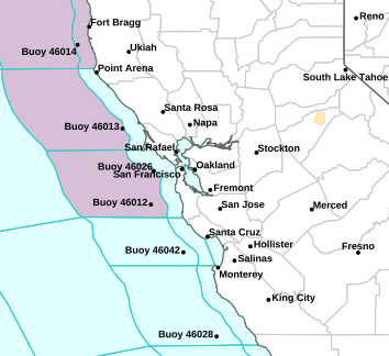
National Weather Service alerts map for your zone/county. The color key table only shows the keys for alerts that are active in your specified county or zone and only shows one alert for each spot on the map, even when more than one alert may be active at that spot. According to the NWS, when there are multiple alerts for a single spot, 'only the most significant threat to life or property is displayed on the map.'
|
||||
| Heat Advisory | ||||
You may also obtain far more information about this weather alert by clicking on this link to
the National Weather Service Forecast Office's report for your forecast region.
(Alerts are from the National Weather Service's CAP v1.2 JSON Feed)
Weather Forecast | ||||||||
| Forecast Created by Experimental Software Written By an Amateur With No Guarantee or Warranty or Promise of Accuracy Provided or Implied! Use at Your Own Risk! You Assume All Risk and Liability If You Use This Information in Any Way, For Any Purpose Whatsoever! See the Disclaimer Given Above! | ||||||||
|
raw forecast data generated on Mon, 03 Aug 2026 05:20:01 -0700 (PDT) |
||||||||
|
Click here for an official National Weather Service forecast! NWS Disclaimer |
||||||||
|
| Sunday Night |
Low of 59. Mostly clear through the night. Humidity 81% through the night. Winds are a light air, W at 2 mph, gusting to a light breeze, 5 mph. |
| Monday |
High of 96. Mostly sunny in the morning, with any clouds clearing to become sunny by the afternoon. Humidity 80% in the morning, lowering to 34% by the afternoon. Winds will be a light breeze, NW-ENE at 2-5 mph, gusting to a gentle breeze, 5-10 mph. Gusting winds stronger in the afternoon. |
| Monday Night |
Low of 60. Clear in the evening, with a few clouds later making it mostly clear after midnight. Humidity 38% in the evening, rising to 75% after midnight. Winds will be a light air, NNW-NE at 1-3 mph, gusting to a light breeze, 2-6 mph. |
| Tuesday |
High of 95. Mostly sunny in the morning, with any clouds clearing to become sunny by the afternoon. Humidity 74% in the morning, lowering to 35% by the afternoon. Winds will be a light breeze, S-WNW at 2-5 mph, gusting to a gentle breeze, 5-10 mph. Winds stronger in the afternoon. |
| Tuesday Night |
Low of 59. Clear in the evening, with a few clouds later making it mostly clear after midnight. Humidity 35% in the evening, rising to 78% after midnight. Winds will be a light air, S-WNW at 1-3 mph, gusting to a gentle breeze, 2-9 mph. Gusting winds stronger in the evening. |
| Wednesday |
High of 91. Mostly sunny in the morning, with any clouds clearing to become sunny by the afternoon. Humidity 78% in the morning, lowering to 35% by the afternoon. Winds will be a light air, S-W at 1-3 mph, gusting to a gentle breeze, 3-10 mph. Gusting winds stronger in the afternoon. |
| Wednesday Night |
Low of 59. Mostly clear through the night. Humidity 39% in the evening, rising to 75% after midnight. Winds will be a light breeze, SW-W at 1-5 mph, gusting to a gentle breeze, 2-9 mph. Winds weaker in the evening. |
| Thursday |
High of 93. Mostly sunny in the morning, with any clouds clearing to become sunny by the afternoon. Humidity 81% in the morning, lowering to 44% by the afternoon. Winds will be a light air, WNW at 3 mph, gusting to a light breeze, 1-6 mph. Gusting winds stronger in the afternoon. |
| Thursday Night |
Low of 62. Mostly clear through the night. Humidity 38% in the evening, rising to 70% after midnight. Winds will be a light breeze, WNW-NW at 1-6 mph, gusting to a gentle breeze, 2-10 mph. Winds weaker in the evening. |
| Friday |
High of 95. Mostly sunny in the morning, with any clouds clearing to become sunny by the afternoon. Humidity 70% in the morning, lowering to 40% by the afternoon. Winds will be a light air, NW at 3 mph, gusting to a light breeze, 2-6 mph. Gusting winds stronger in the afternoon. |
| Friday Night |
Low of 64. Mostly clear in the evening, with any clouds clearing to become clear after midnight. Humidity 34% in the evening, rising to 61% after midnight. Winds will be a light breeze, NW at 0-6 mph, gusting to a gentle breeze, 1-12 mph. Winds weaker in the evening. |
| Saturday |
High of 95. Sunny through the day. Humidity 65% in the morning, lowering to 38% by the afternoon. Winds will be a light air, S-WNW at 3 mph, gusting to a light breeze, 1-6 mph. Gusting winds stronger in the afternoon. |
| Saturday Night |
Low of 62. Clear in the evening, with a few clouds later making it mostly clear after midnight. Humidity 34% in the evening, rising to 65% after midnight. Winds will be a light breeze, W-WNW at 1-6 mph, gusting to a moderate breeze, 2-13 mph. Winds weaker in the evening. |
| Sunday |
High of 89. Mostly sunny in the morning, with any clouds clearing to become sunny by the afternoon. Humidity 77% in the morning, lowering to 51% by the afternoon. Winds will be a light air, SW-W at 1-3 mph, gusting to a light breeze, 2-7 mph. Winds stronger in the afternoon. |
|
The above Experimental Forecast used the National Weather Service's NDFD XML Feed for Saratoga, CA (37.263°N, 122.003°W, NWS Zone CAZ513, NWS County CAC085) |
About this weather station:
| Latitude: | 37° 15.75' N |
| Longitude: | 122° 00.20' W |
| Altitude: | 376 feet |
This station uses a Vantage Pro2, controlled by 'WeeWX', an experimental weather software system written in Python. Weewx was designed to be simple, fast, and easy to understand by leveraging modern software concepts.
WeeWX uptime: 4 days, 3 hours, 0 minutes
Server uptime: 4 days, 3 hours, 0 minutes
weewx v5.3.1
Today's Almanac
| Start civil twilight: | 05:45:00 |
| Sunrise: | 06:14:14 |
| Transit: | 13:14:11 |
| Sunset: | 20:13:36 |
| End civil twilight: | 20:42:45 |
| Prev. Day Length: | 14:01:12 |
| Curr. Day Length: | 13:59:22 |
| Curr. Shorter by: | 00:01:50 |
| Azimuth: | 58.5° |
| Altitude: | -10.5° |
| Right ascension: | 133.7° |
| Declination: | 17.4° |
| Equinox: | 09/22/26 17:05:09 |
| Solstice: | 12/21/26 12:49:59 |
| Rise: | 22:45:02 |
| Transit: | 04:44:55 |
| Set: | 11:20:55 |
| Duration Seen: | 12:36 |
| Azimuth: | 196.2° |
| Altitude: | 57.7° |
| Right ascension: | 6.5° |
| Declination: | 5.9° |
| New moon: | 08/12/26 10:36:39 |
| Full moon: | 08/27/26 21:18:26 |
| Phase: | Waning gibbous (77% full) |